Climate Change Is So Bad, Even the Arctic Is On Fire
From Siberia to Brazil, wildfires are moving underground and burning up massive carbon deposits. The resulting emissions threaten to worsen global warming.
The Arctic tundra. The vast floodplains of Brazil. Indonesian peatlands. In these disparate locales, a particular breed of wildfire is burning up huge stores of carbon and threatening to worsen global warming.
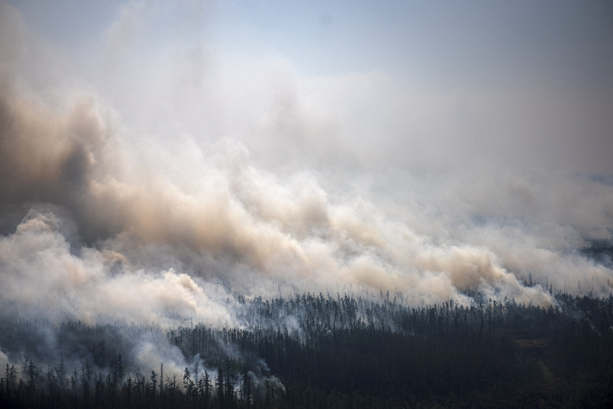
What sets these fires apart is their tendency to move below ground into carbon-rich soil layers. While wildfires generally flame upwards — quickly consuming forest and grassland — the increasingly intense blazes of recent years move downward, where they smolder flamelessly below the surface, consuming layers of organic material.
These little-studied fires are becoming more common as severe wildfires have doubled in frequency over the past two decades. In the Arctic, 2024 is shaping up to be the worst fire year since 2020, when blazes burning across Siberia for several months consumed 8.6 million acres of tundra and sent emissions surging to a record.
Carbon Emissions From Arctic Rising With More Wildfires
- 2024 wildfires
- Arctic and subarctic regions:
- Tundra
- Boreal forest
Sources: NASA Fire Information for Resource Management System; CAMS global biomass burning emissions based on fire radiative power; Copernicus; World Wildlife Foundation Terrestrial Ecoregions of the World
* As of Sept. 19, 2024
Underground fires burn low and slow, and can emit massive quantities of atmosphere-warming greenhouse gases. They’re also triggering feedback loops that make vast landscapes more vulnerable to future fires. That undercuts nations’ progress on fighting climate change — progress that has already been “insufficient to keep the planet safe,” as Brazilian President Luiz Inácio Lula da Silva said Sunday ahead of the United Nations General Assembly and the annual Climate Week event, both held in New York City.
The Arctic
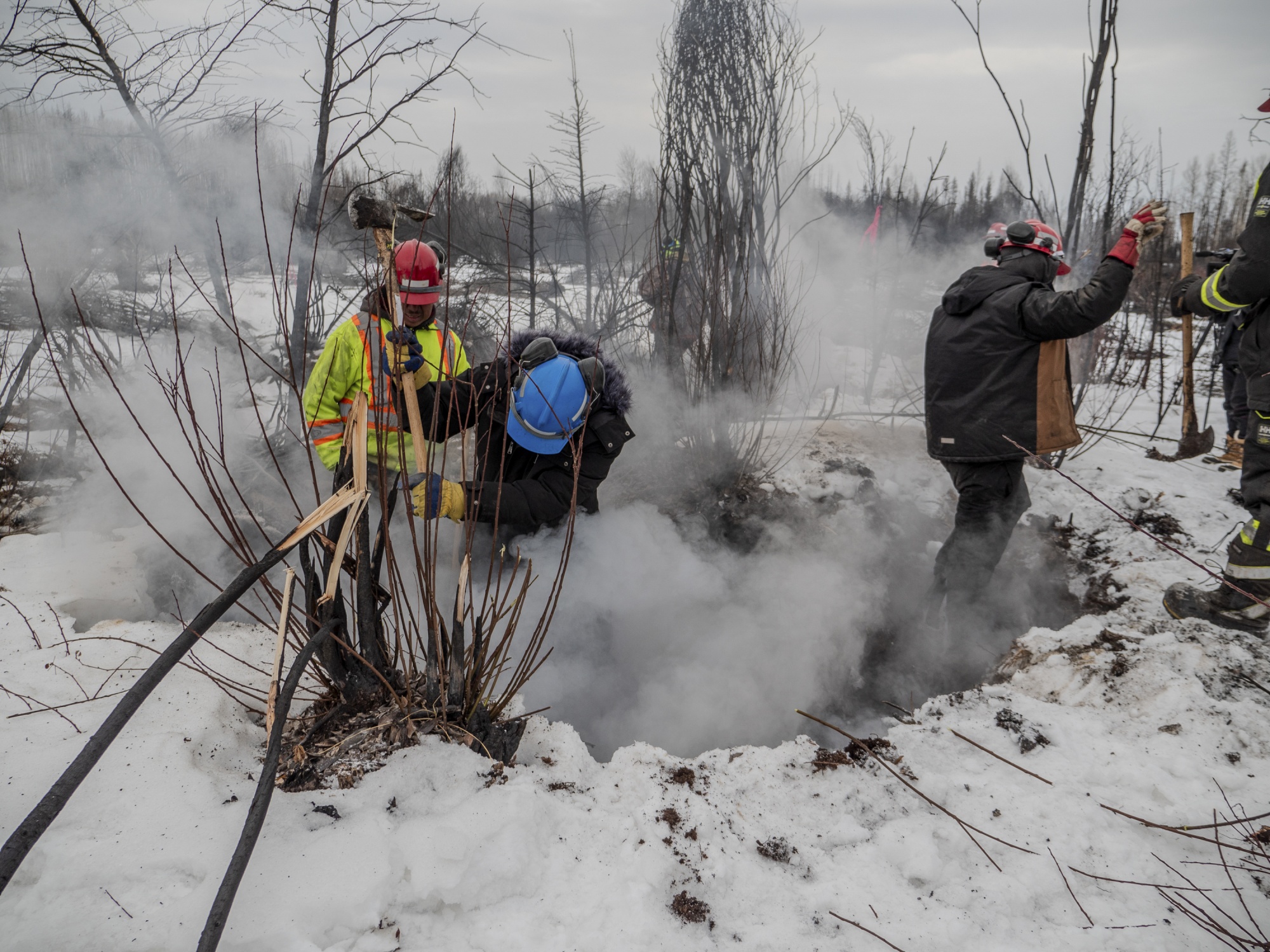
Alberta firefighters responding to boreal wildfires still burning from the 2023 wildfire season in Fox Lake, Alberta, Canada, in February 2024. Photographer: Government of Alberta
Johann Goldammer has studied wildfire for 50 years, from the coldest parts of the world to the hottest. You can tell when a blaze moves underground, he says, by its smell.
The rich organic material beneath the surface produces an odor that’s nasty and acidic. “It’s a smell that triggers more fear,” says Goldammer, who is director of the Global Fire Monitoring Center at the University of Freiburg. “This is where fire doesn’t belong.”
The Arctic is home to most of the world’s carbon-rich peat — a spongy type of soil made from prehistoric vegetation. Historically, tundra that was either frozen in winter or damp in summer protected underground layers of peat from occasional blazes.
But today’s Arctic is much hotter — it is warming faster than any other region on Earth — and wet peat below the surface is drying out. When it ignites, it tends to keep burning, creeping below the surface at a snail’s pace, smoldering for months and is extremely difficult to extinguish.
Far More Arctic Fires Than Normal This Year
Source: NASA Fire Information for Resource Management System
Note: Fire data as of Sept. 17, 2024. Daily fire detections charted are based on a rolling 7-day average and detections at 66° N or higher.
The phenomenon isn’t confined to the Arctic Circle. The record-shattering fires that ravaged Canada last year, blanketing New York City and other parts of the US in choking smoke, began as forest fires in the subarctic and lower regions that, in some cases, moved underground where they smoldered beneath snow and ice through the winter and rose to the surface during an unusually dry spring.
The carbon released from burning peat has contributed to skyrocketing emissions in the Arctic Circle, which this year were already the third highest on record by the middle of June, according to the Copernicus Atmosphere Monitoring Service.
It’s a double whammy for global warming: Peat fires accelerate permafrost thawing which, in turn, releases methane into the atmosphere, making the Arctic even hotter. Scientists estimate around one-third of the world’s permafrost will disappear by mid-century under a high-emissions scenario.
A Third of World’s Permafrost Could Melt Away by Mid-Century
- Permafrost extent assuming high-emissions scenario (RCP8.5)
- Current (2000 to 2014 baseline)
- In 2060
- In 2080
Sources: Olli Karjalainen, Juha Aalto, Miska Luoto, Sebastian Westermann, Vladimir E. Romanovsky, Frederick E. Nelson, Bernd Etzelmüller, Jan Hjort; Stockholm University Bolin Centre for Climate Research (Juri Palmtag, Jaroslav Obu, Peter Kuhry, Matthias Siewert, Niels Weiss, Gustaf Hugelius)
While these smoldering fires don’t flame, they do produce a type of soot known as black carbon. When that’s deposited on sea ice, the potential for another feedback loop exists, with the darkened ice absorbing the sun’s heat rather than reflecting it away from the planet. Scientists are increasingly concerned about what this could mean for the Arctic, and the atmosphere, if the fires keep intensifying.
But a more immediate concern for some scientists is the extent to which such fires permanently alter landscapes. In Siberia, there are already signs that some forests are not recovering; instead, burned land is being seeded by grasses that ignite more easily, creating yet another fire feedback loop, according to Goldammer.
The Pantanal
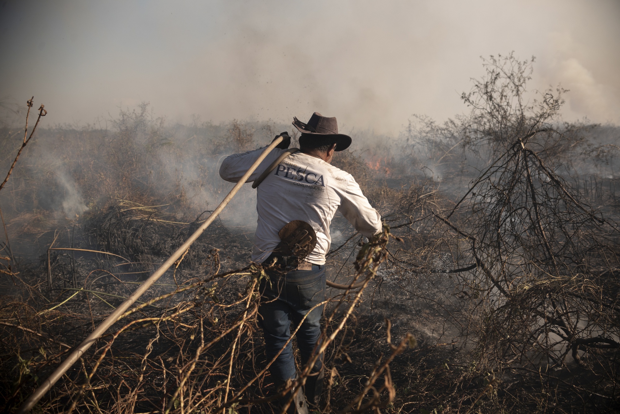
Divino Bispo Santiago, a 55-year-old field foreman, working alongside firefighters and brigadiers to contain the flames in Corumba, Brazil, located within the Pantanal biome on July 2, 2024. Photographer: Gustavo Basso/NurPhoto/Getty Images
The presence of peat supercharges the carbon emissions of a wildfire. That’s why the blazes ravaging Brazil’s Pantanal — the world’s largest wetland containing massive stores of peat — have been so devastating.
Peat only covers 3% to 4% of the Earth’s surface, but holds up to one-third of the world’s soil carbon, according to the United Nations Environment Programme. It’s built up its store of carbon over thousands of years and, when it burns, that carbon can’t all be reabsorbed by new vegetation. That means its impact is far greater.
The combination of this year’s Pantanal fires, along with severe fires in the Amazon, has already had a devastating impact on Brazil’s air quality, according to data released this week by Copernicus. As of mid-September, the country’s wildfire carbon emissions for 2024 were already higher than the previous record for all of 2010.
By August of this year, more than 1.3 million hectares had burned, according to one study. As in the Arctic, climate change has brought hotter, drier conditions to the Pantanal, a trend exacerbated by this year’s El Niño weather pattern. Ranchers, accustomed to regularly burning grass in the wetland to create pastures, suddenly find the blazes can no longer be controlled.
Ane Alencar, science director at IPAM, the Amazon Environmental Research Institute, has been studying fires in the region for 30 years. In 2021, she followed firefighters to a remote area of the Pantanal where a farmer, in the process of digging a protective fire break, had accidentally ignited a bone-dry field when his tractor sparked against a stone. “When we arrived, three or four hours after the call, it was already huge,” she recollects. “That fire burned five farms.”
The same year, she visited a site where a 25-hectare patch of trees in the middle of a wetland had been obliterated by flames, something that normally wouldn’t happen. Until then, she didn’t know such forested “islands” could burn at all.
As in the boreal forest, it’s unclear the extent to which the area can recover. Seeds need to survive the heat along with enough animals to disperse them. “If fire is becoming more frequent, and more intense, it’s more likely to change the diversity even of places more adapted to fire, like Pantanal,” Alencar says.
Indonesia’s Peatlands
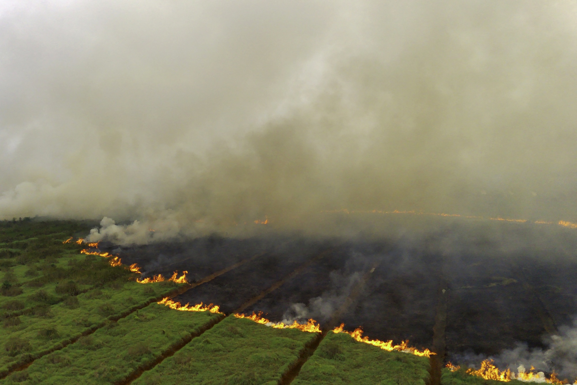
A peatland fire spreading through a plantation in Ogan Ilir, South Sumatra, on Oct. 2, 2023. Photographer: Al Zulkifli/AFP/Getty Images
Because peat fires tend to be underground, they’re extremely difficult to extinguish. The blazes that have devoured Indonesia’s peatlands in recent years are sometimes so deep, firefighters see no visible flame — only white smoke pouring from ground fissures.
To combat the blazes, they create fire suppression holes using piercing nozzles to inject water directly into the ground, an arduous and potentially dangerous task.
While climate change and weather play a role, a bigger factor in Indonesia and places like it is the degradation of peatland. The country’s wetlands have been drained for decades to irrigate crops while trees and brush are also commonly cleared for agriculture. That exposes vast, underground peat deposits to fire risk.
Indonesia’s Degraded Peatlands Release the Most Carbon
Source: Global Peatland Database compiled by the Greifswald Mire Centre
Note: Calculations are based on the peatland drained area for forestry, agriculture and peat extraction and IPCC (2014) emission factors including CO2, CH4, N2O, DOC, and emissions from ditches. Includes only net, on-site emissions.
The subsurface nature of these fires poses another challenge — quantifying their emissions. Without visible flame, satellites can’t see the fires.
“If the satellite sensors we rely on are not able to see those fires, then we can’t estimate the emissions,” says Parrington. That means peat fires, if they’re even detected, could have greater climate impacts than we understand.
A case in point: Emissions from the 2023 Canadian fires that consumed both boreal forest and peatland were higher than burning fossil fuels in almost every country in the world that year.
Reducing wildfire emissions, especially from carbon-intensive peat blazes, requires changes to human behavior in regions that are becoming more vulnerable to burning, as well as better land management strategies and more robust fire-fighting resources.
“I refer to it as the confluence of climate, fuels and people. And all three are connected,” said Tim Brown, a research professor at the Desert Research Institute in Reno Nevada.